Leica Geosystems Again Counts on Getac to Make Hidden Utility Networks Visible
Leica DSX and the Getac F110 rugged tablet enable quick and secure localization, visualization and mapping of underground utilities
PR Newswire
IRVINE, California, Oct. 17, 2019
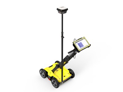
IRVINE, California, Oct. 17, 2019 /PRNewswire/ — Getac today announced that Leica Geosystems has selected its fully rugged F110 tablet to provide utility companies, repair and maintenance contractors, surveyors and civil engineers with a complete, intelligent solution for detecting, visualizing and mapping underground utilities. Leica Geosystems combines the tablet with its own Leica DSX utility detection solution to provide highly reliable subterraneous information on any terrain and in any weather conditions.

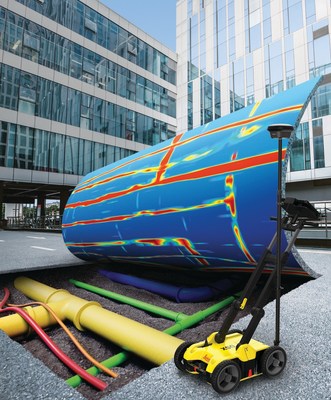
Leica Geosystems develops high-quality, reliable and robust solutions for detection of buried utilities. The latest DSX solution simplifies the way traditional ground-penetrating radar data is visualized, interpreted and exported with the support of Getac F110 tablet.
Locating and mapping of invisible underground utilities that are typically undocumented is a lengthy task that used to be limited to highly experienced professionals with technical background. Leica Geosystems’ DSX utility detection and mapping solution allows new users with limited experience in interpreting ground penetrating radar data to take advantage of the benefits the technology has to offer – assuring safety during excavation works by reducing the risk of utility strikes. This in turn helps minimize downtime and opens up new service opportunities.
Underground utility detection and mapping is performed on all types of conditions and terrain, ranging from asphalt, and gravel to grass, rocks and sand. Being part of the solution, it is crucial that the tablet remains stable, has a high-resolution display for clear data visualization and analysis, works reliably in sunlight and rain, as well as in hot and cold temperatures.
“We distribute our solutions worldwide, so the tablets need to be able to cope with any kind of climate and environmental conditions,” says Agata Fischer, Business Director Detection and Services at Leica Geosystems. “In addition, they must be able to withstand rough handling including knocks and drops.”
For just such cases, the fully-rugged F110 Tablet is independently tested and certified to MIL-STD 810G, IP65 and MIL-STD-461F standards, meaning it is protected against drops of up to 1.2 metres, shocks, spills, vibration, dust, liquid and more. It can also be operated in temperatures from -21 to +60 ° C and stored in temperatures from -51 to +71 ° C.
“Getac’s industry-leading bumper-to-bumper warranty, which includes accidental damage, means Leica Geosystems’ customers can purchase the new solution in complete confidence that their investment is fully protected,” added Fischer.
The location of buried utilities must often be done in a wide range of weather conditions. The F110 tablet features Getac’s LumiBond® 2.0 display, which is fully legible even in direct sunlight, while various touch modes for rain, glove or pen operation ensure a high level of user-friendliness. The large 11.6-inch screen also offers ample space for applications, while the RJ45 / LAN port provides a secure and fast data connection to the DSX utility detection system.
Scott Shainman, President of Getac North America, explains: “We are very pleased that Leica Geosystems has chosen us again, and especially for this demanding, innovative solution. Their application is not just about maximizing efficiency and avoiding costly damage to pipelines, but above all, protecting their colleagues doing difficult and often extremely dangerous work outside in the field. Our highly reliable and powerful F110 tablet is definitely the best choice for such requirements.”
Leica Geosystems – When it has to be right
Revolutionising the world of measurement and survey for nearly 200 years, Leica Geosystems, part of Hexagon, creates complete solutions for professionals across the planet. Known for premium products and innovative solution development, professionals in a diverse mix of industries, such as aerospace and defence, safety and security, construction, and manufacturing, trust Leica Geosystems for all their geospatial needs. With precise and accurate instruments, sophisticated software, and trusted services, Leica Geosystems delivers value every day to those shaping the future of our world.
Hexagon is a global leader in sensor, software and autonomous solutions. We are putting data to work to boost efficiency, productivity, and quality across industrial, manufacturing, infrastructure, safety, and mobility applications. Our technologies are shaping urban and production ecosystems to become increasingly connected and autonomous — ensuring a scalable, sustainable future. Hexagon (Nasdaq Stockholm: HEXA B) has approximately 20,000 employees in 50 countries and net sales of approximately 3.8bn EUR. Learn more at hexagon.com and follow us @HexagonAB.
About Getac
Getac is a major subsidiary of MiTAC-Synnex Business Group (Group revenue 2018: $ 38 billion). Getac Technology Corporation was founded in 1989 as a joint venture with GE Aerospace to deliver electronic defense equipment. Today, Getac’s businesses include rugged notebooks and rugged tablets not just for military customers, but also for the automotive and process industries, police, fire, utilities, manufacturing, transportation, and logistics. Learn more at www.getac.com.
© 2019 Getac Technology Corporation. All rights reserved. Getac and the Getac logo are either registered trademarks or trademarks of Getac Technology Corporation in the United States and / or other countries. All other brands and product names are trademarks or registered trademarks of their respective companies.


![]() View original content to download multimedia:http://www.prnewswire.com/news-releases/leica-geosystems-again-counts-on-getac-to-make-hidden-utility-networks-visible-300939995.html
View original content to download multimedia:http://www.prnewswire.com/news-releases/leica-geosystems-again-counts-on-getac-to-make-hidden-utility-networks-visible-300939995.html
SOURCE Getac
